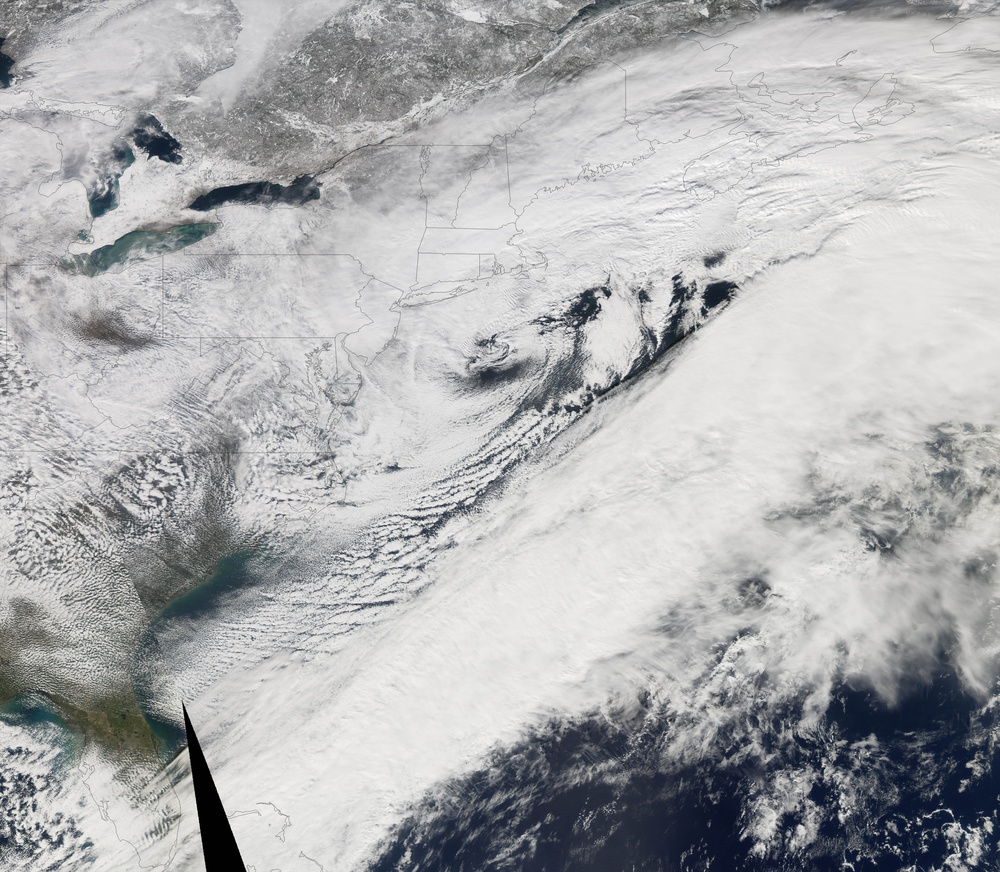
The East Coast of the United States went from balmy, spring-like weather to winter white overnight between February 11 and 12, 2006. A powerful nor'easter moved up the coast from the Gulf of Mexico settling heavy snow from Virginia to Massachusetts. New York City bore the brunt of the storm, with totals in Central Park at the city's center reaching 26.9 inches, reported the National Weather Service. The storm gave New York City more snow than any other storm since records began in 1869. The heavy snow closed all three of New York City's airports as well as National Airport outside of Washington, D.C., said the New York Times.
All of the ingredients for a classic nor'easter were present when the storm developed. In general, nor'easters form when a low-pressure system brings warm, wet air from the Gulf of Mexico up the East Coast, where it meets cold Arctic air. As the two systems mix, the air cools, and heavy rain or snow is unleashed. The resulting storm gets its name from the strong northeastern winds that are generated by the pressure difference between the Arctic front and the low-pressure system. If a nor'easter forms rapidly, as the storm on February 11 and 12 did, the winds can begin to circle counterclockwise around the low-pressure center of the storm.
The storm was starting to exhibit counterclockwise circulation on February 12, when the Moderate Resolution Imaging Spectroradiometer ( modis.gsfc.nasa.gov MODIS ) on NASA's aqua.nasa.gov/ Aqua satellite captured this image. The top edge of the storm (top right) circles around a rare eye-like center over Long Island. The thick band of clouds that made up the rest of the storm had already been blown off the coast, though plenty of residual clouds lingered over the storm-hit region. On eoimages.gsfc.nasa.gov/images/imagerecords/16000/16106/noreaster_TMO_2006042.jpg February 11 , the distinct band of clouds seen on the right side of this image stretched from the Gulf of Mexico up to New England, showing the path of the storm. The highest snowfall totals on February 12 as reported by the /NaturalHazards/Archive/Feb2006/1dayaccum_12Feb06.jpg National Weather Service follow the track of this band of clouds.
The image shown above is a composite of two satellite overpasses from two different times. A faint diagonal line separates the two, and the black wedge at the bottom of the image shows where the satellite collected no data.
NASA image by Jesse Allen using data provided by the rapidfire.sci.gsfc.nasa.gov MODIS Rapid Response Team at NASA GSFC.
| Date Taken: | 07.27.2011 |
| Date Posted: | 10.18.2012 00:16 |
| Photo ID: | 738729 |
| Resolution: | 6119x5336 |
| Size: | 4.68 MB |
| Location: | WASHINGTON, DISTRICT OF COLUMBIA, US |
| Web Views: | 4 |
| Downloads: | 0 |
