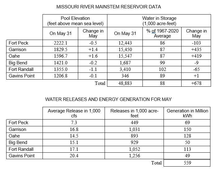
MISSOURI RIVER MAINSTEM RESERVOIR DATA
Pool Elevation
(feet above mean sea level) Water in Storage
(1,000 acre-feet)
On May 31 Change in May On May 31 % of 1967-2020 Average Change in May
Fort Peck 2222.1 -0.5 12,443 86 -103
Garrison 1829.5 +1.4 15,450 87 +435
Oahe 1596.7 +1.6 15,547 87 +419
Big Bend 1421.0 -0.2 1,687 99 -9
Fort Randall 1355.0 -1.1 3,410 102 -65
Gavins Point 1206.8 -0.1 346 89 +1
Total 48,883 88 +678
WATER RELEASES AND ENERGY GENERATION FOR MAY
Average Release in 1,000 cfs Releases in 1,000 acre-feet Generation in Million kWh
Fort Peck 7.3 449 69
Garrison 16.8 1,031 150
Oahe 14.5 893 128
Big Bend 15.1 929 50
Fort Randall 17.1 1,052 113
Gavins Point 20.4 1,256 49
Total 559
| Date Taken: | 06.08.2022 |
| Date Posted: | 06.08.2022 11:40 |
| Photo ID: | 7260417 |
| VIRIN: | 220608-A-A1408-002 |
| Resolution: | 696x549 |
| Size: | 78.75 KB |
| Location: | OMAHA, NEBRASKA, US |
| Web Views: | 7 |
| Downloads: | 3 |

This work, Below average runoff forecasts for upper Missouri River Basin continue [Image 2 of 2], must comply with the restrictions shown on https://www.dvidshub.net/about/copyright.