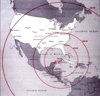
This map of the western hemisphere shows the range of Soviet medium-range (SS-4 SANDAL) and intermediate-range (SS-5 SKEAN) ballistic missiles from Cuba across the Continental United States (CONUS). It was used by the Kennedy administration in its deliberations over the crisis. It shows that the full deployment of Soviet nuclear ballistic missiles in western Cuba would have threatened most of the CONUS except for the Pacific Northwest corner of the country. (JFK Presidential Library and Museum)
| Date Taken: | 10.27.2022 |
| Date Posted: | 10.27.2022 15:13 |
| Photo ID: | 7483212 |
| VIRIN: | 221027-Z-F3895-0009 |
| Resolution: | 335x320 |
| Size: | 35.51 KB |
| Location: | PORTLAND, OREGON, US |
| Web Views: | 268 |
| Downloads: | 29 |

This work, Soviet range during Cuban Missile Crisis [Image 10 of 10], must comply with the restrictions shown on https://www.dvidshub.net/about/copyright.